|
|
|||||||||||||||||||||||||||||||||||||||||||||||||||||||||||||||||||||||||||||||||||||||||||||||||||||||||||||||||||||||||||||||||||||||||||||||||||||||||||||||||||||||||||||||||||||||||||||||||||||||||||||||||||||||||||||||||||||||||||||||||||||||||||||||||||||||||||||||||||||||||||||||||||||||||
|
|
|||||||||||||||||||||||||||||||||||||||||||||||||||||||||||||||||||||||||||||||||||||||||||||||||||||||||||||||||||||||||||||||||||||||||||||||||||||||||||||||||||||||||||||||||||||||||||||||||||||||||||||||||||||||||||||||||||||||||||||||||||||||||||||||||||||||||||||||||||||||||||||||||||||||||
 |
|||||||||||||||||||||||||||||||||||||||||||||||||||||||||||||||||||||||||||||||||||||||||||||||||||||||||||||||||||||||||||||||||||||||||||||||||||||||||||||||||||||||||||||||||||||||||||||||||||||||||||||||||||||||||||||||||||||||||||||||||||||||||||||||||||||||||||||||||||||||||||||||||||||||||
|
|
|||||||||||||||||||||||||||||||||||||||||||||||||||||||||||||||||||||||||||||||||||||||||||||||||||||||||||||||||||||||||||||||||||||||||||||||||||||||||||||||||||||||||||||||||||||||||||||||||||||||||||||||||||||||||||||||||||||||||||||||||||||||||||||||||||||||||||||||||||||||||||||||||||||||||
|
State of water environmental issues
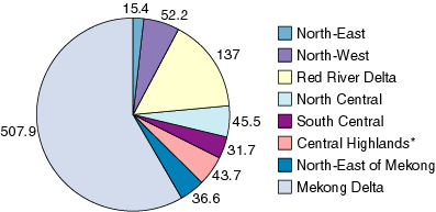
Surface WaterAbout two thirds of Viet Nam’s water resources originate from catchments in riparian countries. Viet Nam is the lower riparian country in the Mekong and Red Rivers and is susceptible to water resource decisions made in upstream countries. This susceptibility exacerbates the highly variable seasonal (droughts in the dry season and flooding in the monsoons) and geographical distribution of water (Fig 2). Despite the total abundant water resources, the dependency on upstream countries and the uneven distribution have made Viet Nam’s ranking low in Southeast Asia’s water availability per capita (4170 m³/person compared to average 4900 m³/person in Southeast Asia and 3300 m³/person in Asia)
Surface water: Rivers Viet Nam has a dense river network of which 2360 rivers have a length of more than 10 km. Eight out of these are large basins with a catchment area of 10,000 km² or more (Table 6). The rivers flowing through Viet Nam include many international rivers. The total area in- and outside Viet Nam of all international catchments is close to 1.2 mill. km², which is approximately 3 times the size of Viet Nam itself. The total annual runoff is 835 bill. m³ but the shortage of water is aggravated in the 6-7 month dry season, when the runoff is only 15 to 30% of this total.
Of the international rivers, the Mekong and the Red rivers are the most important. The Mekong –the longest river in Southeast Asia –drains from China and enters the lower basin at the common Myanmar-Lao PDR-Thailand border point. The 'lower basin' covers some 600,000 km² and includes parts of four countries Lao PDR, Cambodia, Thailand and Viet Nam. The Red River basin is the largest in Viet Nam. The river rises in Yunnan Province in China and flows through the northern part of the country into the Tonkin Gulf, forming an extensive delta. Reservoirs: Most dams and reservoirs in Viet Nam have been constructed for multiple purposes, including flood control, irrigation, hydropower, water supply and other flow management. Most are more than 20-30 years old. There are about 3600 reservoirs of various sizes, of which less than 15 percent are large or medium (capacity of over 1 mill. m³ or a height of more than 10 meters)1. Siltation from degradation of watersheds is causing a decline in reservoir capacity – some with only 30% of the original capacity remaining. (Table 7) Note 1: Nguyen Dinh Trong, Workshop on integrated water management for reservoirs, Hanoi Oct 1994.
Lake: There are several major natural lakes in Viet Nam, one of those is Ba Be lake with a surface area of 4.5 km² and a volume of 90 million m³. In addition, there are numerous other smaller lakes - including urban lakes in Hanoi. Inland Ecosystem:
Only scarce quantitative data are available for inland aquatic ecosystems, and the extent of the deterioration of freshwater biodiversity is still poorly known. However, there are indicators showing that many species are in danger of extinction or becoming rare (Box 1). Listed in the Red Book 2002 (forthcoming) are 6 wetland waterfowl birds, 24 reptiles, 14 amphibian, 37 fish, 19 mollusk and 1 insect freshwater species. In a recent study by the World Bank 268 native freshwater fish species have been recorded only from the Ca River basin northwards, showing that a significant part of the northern Vietnamese fish fauna is shared with southern China5. This study is particular concerned freshwater biodiversity in the context of the Viet Nam National Hydropower Study. The study shows that changes in the hydrological regime of river systems due to construction of dams for irrigation and hydropower causes loss of migrating routes for many species like the Clupanodon thrissa in the Red River and eels Anguilla spp. in various rivers in Viet Nam.
Surface Water Quality: In Viet Nam, data on surface water quality is poor. However, limited testing reveals rising pollution levels in downstream sections of the major rivers. The upstream water quality of most rivers remains good, while downstream pollution mainly from urban areas and industries affects the water quality (Table 8).
The National Monitoring Network (NMN) covers 4 rivers running through the main urban areas of Viet Nam, Red River (Hanoi), Cam River (Haiphong), Huong River (Hue) and Saigon River (HCM City). However, other rivers are monitored as well in the various regions (Table 9).
Trends indicate that the levels of two primary pollution indicators, Ammonia-nitrogen (NH4-N) and Biochemical Oxygen Demand (BOD5) vary considerably and exceed national water quality class A standards by several fold (Fig 4 and Fig 5). The problems are worst during the dry season, when the flows in the rivers are reduced.
Industrial and other pollution adds to the human waste from the population. Around 70 industrial parks have been developed, and with more than 1,000 hospitals nationwide some million cubic meters of untreated wastewater is discharged from these sources alone per day. According to MoNRE, there are about 4,000 enterprises discharging wastewater, of which 439 enterprises are the most serious, and are required reallocated, closed or will have to adapt cleaner technologies and treatment of their wastewater. Rivers in Viet Nam's urban areas, especially major cities, are seriously polluted by untreated industrial wastewater. Surveys conducted by the Institute of Tropical Techniques and Environmental Protection show that the content of contaminants in rivers in Hanoi, Ho Chi Minh City, Hai Phong, Hai Duong, Bac Giang, Hue, Da Nang, Quang Nam and Dong Nai, are much higher than permissible levels9. Untreated industrial wastewater discharging into rivers is the main source of the pollution. According to the institute, industrial parks (IPs) and export processing zones (EPZs) in the Southern Key Economic Zone discharge over 137,000 m³ of wastewater containing nearly 93 tons of waste into the Dong Nai, Thi Vai and Saigon Rivers each day. Meanwhile, two out of 12 IPs and EPZs in Ho Chi Minh City, three out of 17 in Dong Nai, two out of 13 in Binh Duong, and none of the IPs and EPZs in Ba Ria-Vung Tau have wastewater treatment facilities. According to environmentalists the Southern Key Economic Zone needs investment of 5.7 trill. VND (380 mill. USD) in 2005 and 13 trill. VND (867 mill. USD) in 2010 to deal with environmental pollution. Within cities, lakes, streams, and canals increasingly serve as sinks for domestic sewage, municipal, and industrial wastes. Most of the lakes in Hanoi are seriously polluted with high BOD levels. Similarly, 4 small rivers in Hanoi and 5 canals in HCM City have levels of DO as low as 0-2 mg/l, and BOD levels as high as 50-200 mg/l (Table 10).
|
|||||||||||||||||||||||||||||||||||||||||||||||||||||||||||||||||||||||||||||||||||||||||||||||||||||||||||||||||||||||||||||||||||||||||||||||||||||||||||||||||||||||||||||||||||||||||||||||||||||||||||||||||||||||||||||||||||||||||||||||||||||||||||||||||||||||||||||||||||||||||||||||||||||||||


| pagetop |
| POLICIES | TECHNOLOGIES | NGOs & CBOs | SOURCES |
| Home | About WEPA | What's new | Activities | Definitions | Link | Sitemap | Contact Us |
|